Map of Louisiana Parishes
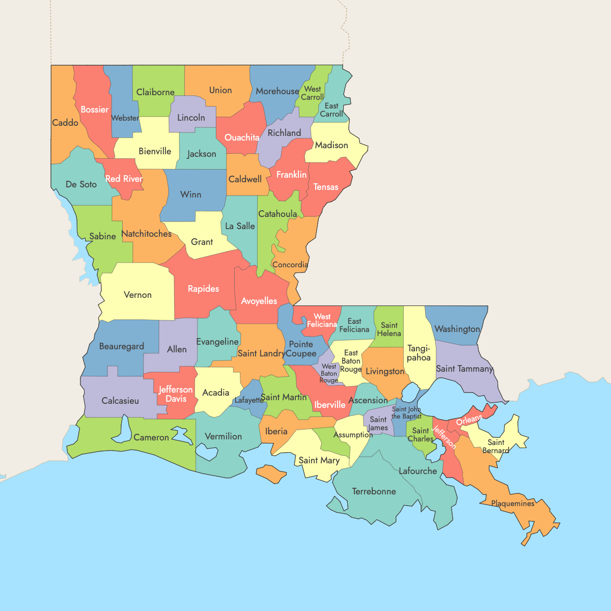
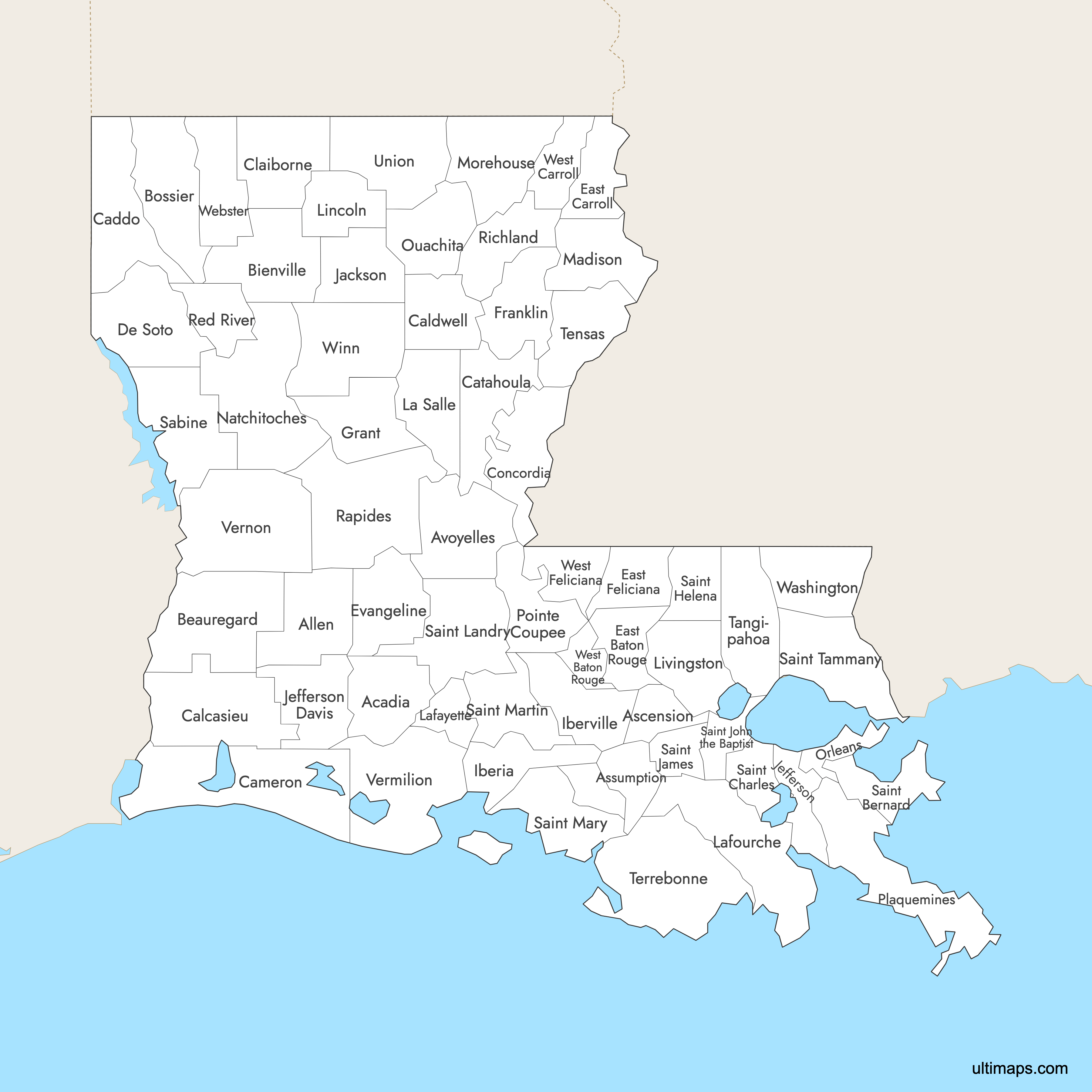
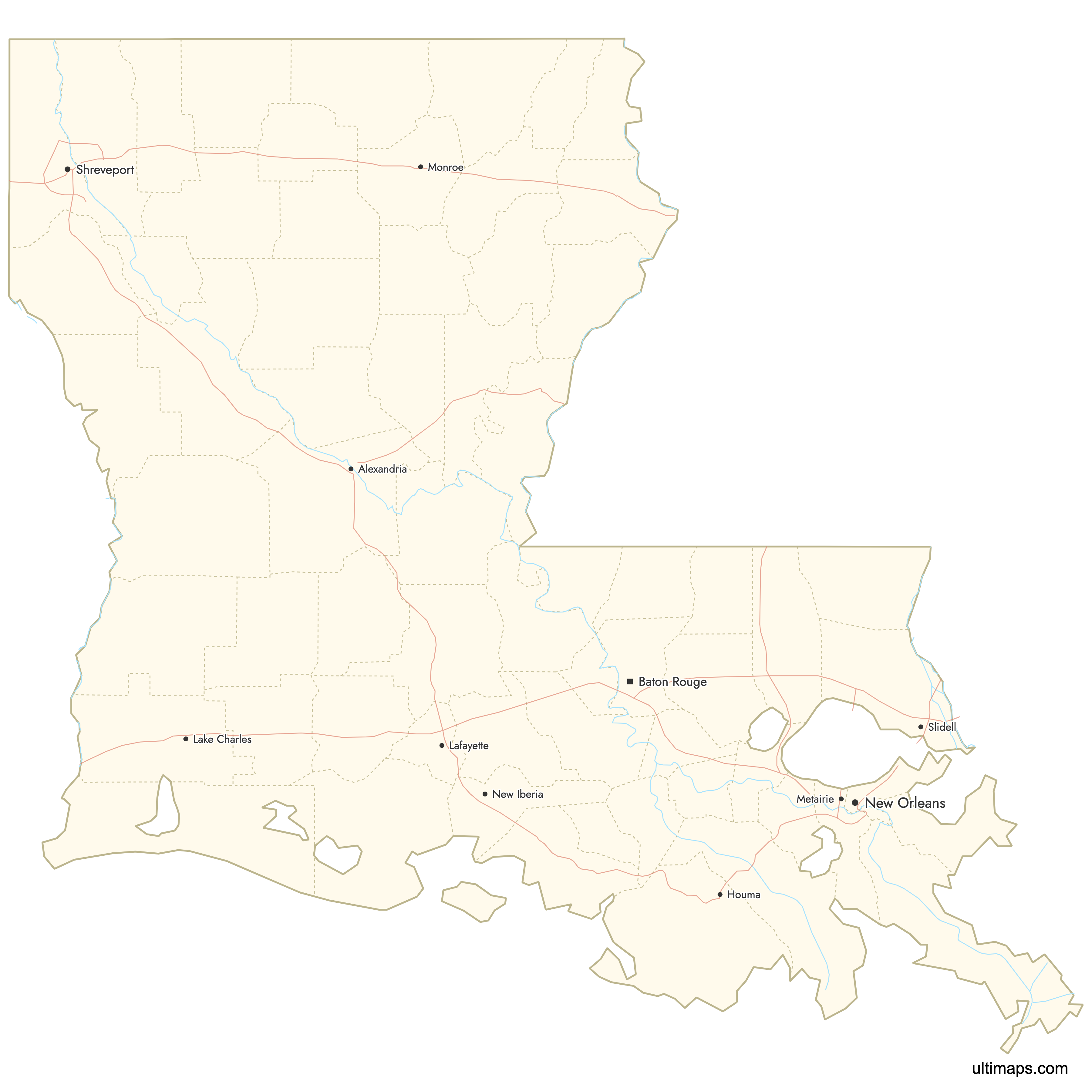
Louisiana is divided into 64 parishes, the only U.S. state to use "parishes" instead of counties as its primary administrative divisions. Stretching from the Arkansas border south to the Gulf of Mexico, these parishes range from dense urban centers like Orleans Parish (New Orleans) to sparsely populated rural areas like Tensas Parish. Use the interactive maps below to explore all 64 parishes and their boundaries. Download free maps or learn more about creating a custom map of Louisiana to visualize your own data.
Interactive Map of Louisiana Parishes
List of Parishes (64)
| # | Parish | County seat | Year founded |
|---|---|---|---|
| 1 | Acadia | Crowley | 1886 |
| 2 | Allen | Oberlin | 1912 |
| 3 | Ascension | Donaldsonville | 1807 |
| 4 | Assumption | Napoleonville | 1807 |
| 5 | Avoyelles | Marksville | 1807 |
| 6 | Beauregard | DeRidder | 1912 |
| 7 | Bienville | Arcadia | 1848 |
| 8 | Bossier | Benton | 1843 |
| 9 | Caddo | Shreveport | 1838 |
| 10 | Calcasieu | Lake Charles | 1840 |
| 11 | Caldwell | Columbia | 1838 |
| 12 | Cameron | Cameron | 1870 |
| 13 | Catahoula | Harrisonburg | 1808 |
| 14 | Claiborne | Homer | 1828 |
| 15 | Concordia | Vidalia | 1807 |
| 16 | De Soto | Mansfield | 1843 |
| 17 | East Baton Rouge | Baton Rouge | 1810 |
| 18 | East Carroll | Lake Providence | 1877 |
| 19 | East Feliciana | Clinton | 1824 |
| 20 | Evangeline | Ville Platte | 1910 |
| 21 | Franklin | Winnsboro | 1843 |
| 22 | Grant | Colfax | 1869 |
| 23 | Iberia | New Iberia | 1868 |
| 24 | Iberville | Plaquemine | 1807 |
| 25 | Jackson | Jonesboro | 1845 |
| 26 | Jefferson | Gretna | 1825 |
| 27 | Jefferson Davis | Jennings | 1912 |
| 28 | La Salle | Jena | 1910 |
| 29 | Lafayette | Lafayette | 1823 |
| 30 | Lafourche | Thibodaux | 1807 |
| 31 | Lincoln | Ruston | 1873 |
| 32 | Livingston | Livingston | 1832 |
| 33 | Madison | Tallulah | 1838 |
| 34 | Morehouse | Bastrop | 1844 |
| 35 | Natchitoches | Natchitoches | 1807 |
| 36 | Orleans | New Orleans | 1807 |
| 37 | Ouachita | Monroe | 1807 |
| 38 | Plaquemines | Pointe a la Hache | 1807 |
| 39 | Pointe Coupee | New Roads | 1807 |
| 40 | Rapides | Alexandria | 1807 |
| 41 | Red River | Coushatta | 1871 |
| 42 | Richland | Rayville | 1868 |
| 43 | Sabine | Many | 1843 |
| 44 | Saint Bernard | Chalmette | 1807 |
| 45 | Saint Charles | Hahnville | 1807 |
| 46 | Saint Helena | Greensburg | 1810 |
| 47 | Saint James | Convent | 1807 |
| 48 | Saint John the Baptist | Edgard | 1807 |
| 49 | Saint Landry | Opelousas | 1807 |
| 50 | Saint Martin | Saint Martinville | 1807 |
| 51 | Saint Mary | Franklin | 1811 |
| 52 | Saint Tammany | Covington | 1810 |
| 53 | Tangipahoa | Amite | 1869 |
| 54 | Tensas | Saint Joseph | 1843 |
| 55 | Terrebonne | Houma | 1822 |
| 56 | Union | Farmerville | 1839 |
| 57 | Vermilion | Abbeville | 1844 |
| 58 | Vernon | Leesville | 1871 |
| 59 | Washington | Franklinton | 1819 |
| 60 | Webster | Minden | 1871 |
| 61 | West Baton Rouge | Port Allen | 1807 |
| 62 | West Carroll | Oak Grove | 1877 |
| 63 | West Feliciana | Saint Francisville | 1824 |
| 64 | Winn | Winnfield | 1852 |
Louisiana Parishes: Key Facts
- Total number of parishes: 64, making Louisiana the only U.S. state to use "parishes" instead of counties as its primary administrative divisions
- Most populous parish: Ouachita Parish (Monroe) with 157,874 residents (2020 Census)
- Least populous parish: Tensas Parish with 3,844 residents (2020 Census)
- Largest parish by area: Plaquemines Parish at 2,429 square miles (6,290 km²)
- Smallest parish by area: West Baton Rouge Parish at 203 square miles (530 km²)
- Major urban centers: Orleans Parish (New Orleans), East Baton Rouge Parish (Baton Rouge), Jefferson Parish (Gretna), Lafayette Parish (Lafayette), St. Tammany Parish (Covington), Calcasieu Parish (Lake Charles), Ouachita Parish (Monroe)
- State capital: Baton Rouge, located in East Baton Rouge Parish
- Borders: Arkansas to the north, Mississippi to the northeast, Texas to the west, and the Gulf of Mexico to the south
- Time zone: Central Time Zone (UTC-6, UTC-5 during daylight saving time) statewide
- Boundary history: The original 19 parishes were established in 1807 upon Louisiana's path to statehood. The current 64 parishes were formed through subdivisions over the following decades, with the most recent parishes (Vernon and Webster) created in 1871.
Interesting Facts
- Louisiana uses "parishes" instead of counties because of its Spanish and French colonial history, where Catholic church parish boundaries served as the basis for civil administration.
- Nine parishes retain Native American names. Ouachita is named after an indigenous people of the region, and Plaquemines derives from a Creole/Atakapa word meaning "persimmons."
- St. Tammany Parish is named after Tamanend, a legendary Lenape chief, and grew to a population of 277,615 by the 2020 Census.
- The Atchafalaya Basin, the largest wetland in the United States, spans across St. Martin, Iberville, and Pointe Coupee parishes.
- In 1807, the original Orleans County was split into three separate parishes: Orleans, St. Bernard, and Plaquemines.
Free Downloads
Free for personal and commercial use with a credit to Ultimaps. See the license terms for details.
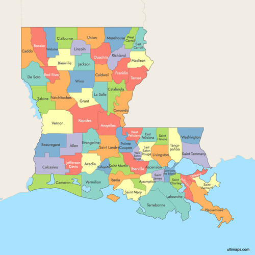 Colored Map of Louisiana Parishes with Surrounding Areaspng941 KB
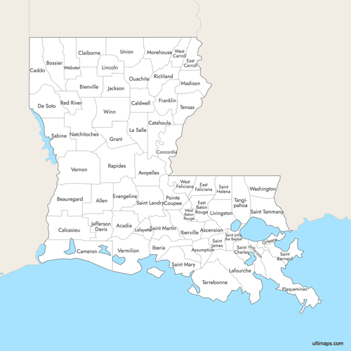 Labeled Map of Louisiana Parishes with Surrounding Areaspng922 KB
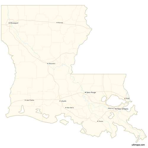 Map of Louisiana Parishes with Citiespng907 KB
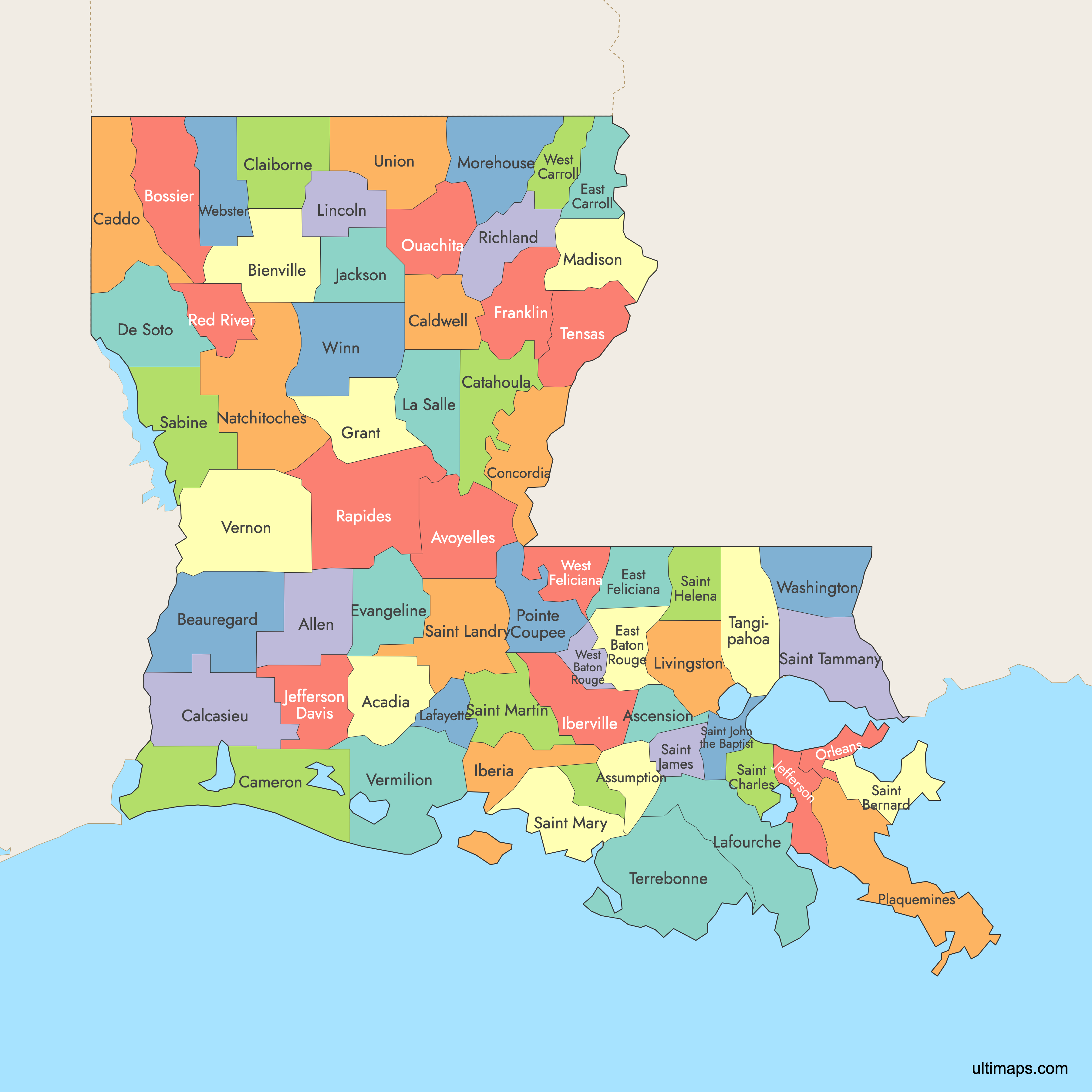
Need it without colors? The blank version of this map comes as a print-ready PDF (A4 and US Letter), a PNG and an editable SVG.
Custom Map Features
This map supports labels.
This map supports surrounding areas, roads, rivers and cities. New
This map is divided into 64 parishes.
Updates
Aug 26, 2024:
- Added map of Louisiana Counties
Frequently Asked Questions
Louisiana has 64 parishes. It is the only U.S. state that uses "parishes" instead of counties as its primary administrative divisions. The term dates back to Louisiana's French and Spanish colonial period, when Catholic church parish boundaries defined civil jurisdictions. The original 19 parishes were established in 1807, and the current 64 were finalized by 1871.
Plaquemines Parish is the largest parish by area at 2,429 square miles (6,290 km²). It stretches southeast of New Orleans along the Mississippi River delta toward the Gulf of Mexico. Its name comes from a Creole/Atakapa word meaning "persimmons."
West Baton Rouge Parish is the smallest parish by area at 203 square miles (530 km²). It sits on the west bank of the Mississippi River, directly across from Baton Rouge, the state capital.
Ouachita Parish is the most populous parish with 157,874 residents according to the 2020 Census. Its parish seat is Monroe, a commercial center in northeastern Louisiana. The least populous parish is Tensas Parish with just 3,844 residents (2020 Census).
Louisiana uses parishes instead of counties because of its French and Spanish colonial heritage. Under colonial rule, the Catholic Church organized the territory into ecclesiastical parishes for administration. When Louisiana became a U.S. territory and later a state, these church-based boundaries carried over into civil government, and the term "parish" was retained. Louisiana is the only state in the U.S. that uses this terminology.
New Orleans, famous for the French Quarter and Mardi Gras, is in Orleans Parish. Baton Rouge, the state capital and home to Louisiana State University, is in East Baton Rouge Parish. Lafayette, a cultural hub known for Cajun heritage, is in Lafayette Parish. Shreveport, the northwest gateway city, is in Caddo Parish. The Atchafalaya Basin, the largest wetland in the U.S., spans St. Martin, Iberville, and Pointe Coupee parishes.
The New Orleans metropolitan area centers on Orleans Parish, which is coterminous with the city of New Orleans. Surrounding parishes include Jefferson Parish (seat: Gretna), St. Tammany Parish (seat: Covington, population 277,615 in 2020), and St. Bernard Parish. Plaquemines Parish, the largest by area at 2,429 square miles, also extends southeast from the metro area along the Mississippi River delta.
The capital of Louisiana is Baton Rouge, located in East Baton Rouge Parish. Baton Rouge is home to the Louisiana State Capitol and Louisiana State University. East Baton Rouge Parish is one of the state's most urbanized parishes.
You can use Ultimaps to create custom maps of Louisiana. Color-code parishes manually or upload your data, place pins, customize the look and feel, and export to PNG, PDF, or SVG. No sign-up required.