Map of Florida Counties
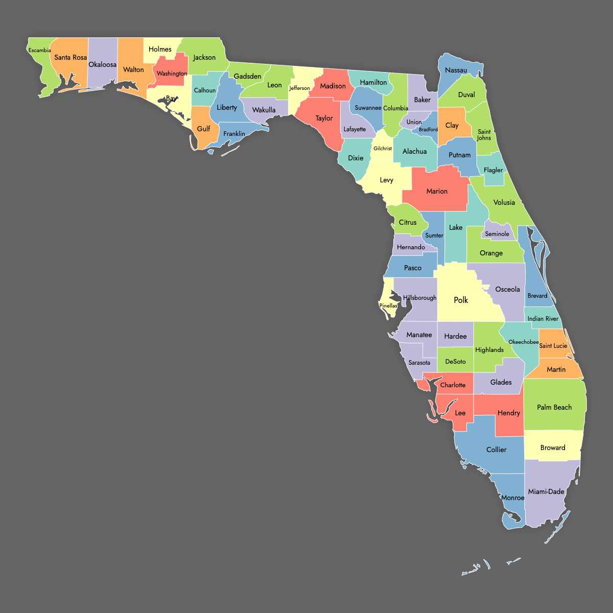
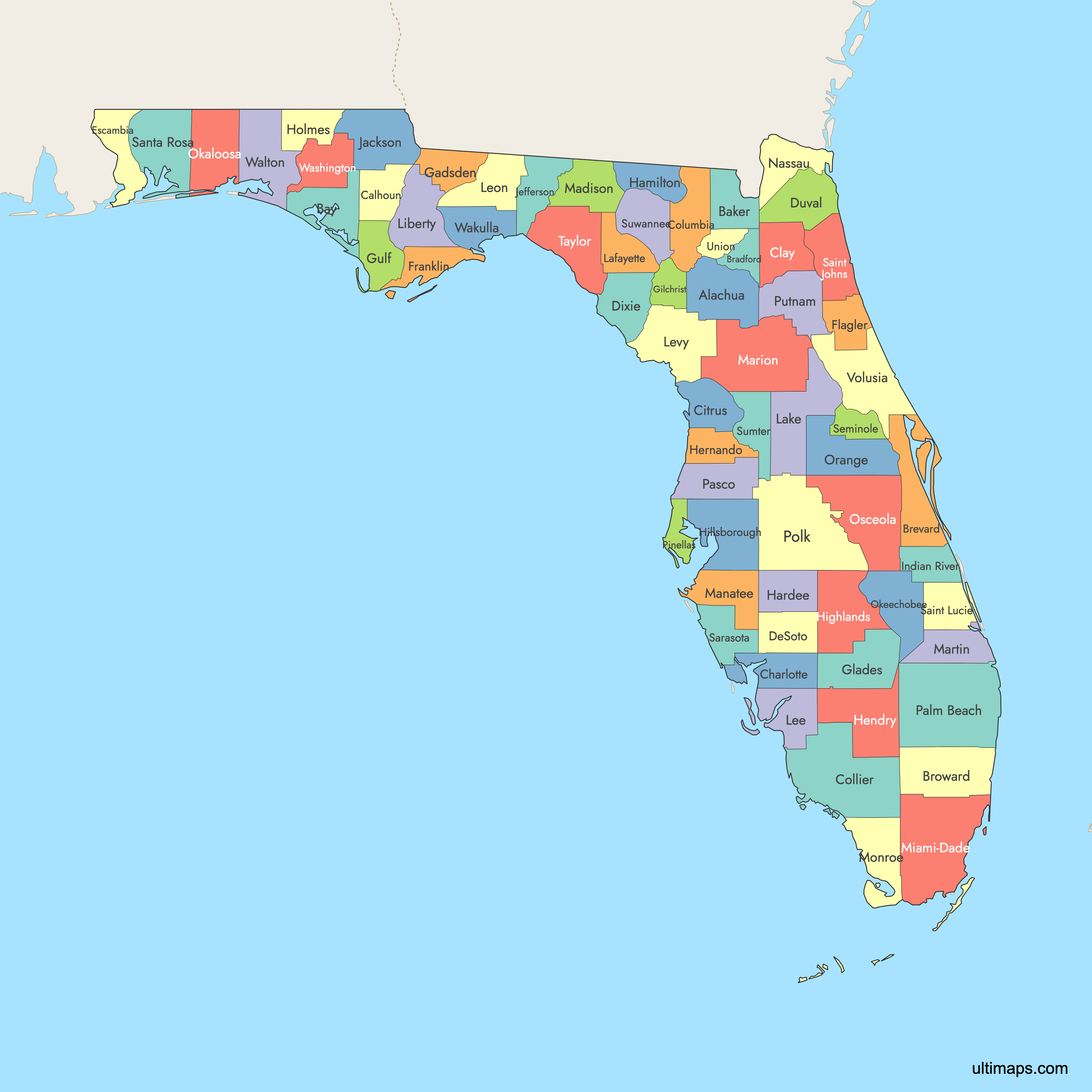
Florida is divided into 67 counties, each with distinct boundaries and county seats. Use the interactive maps below to explore counties and their boundaries. Download free maps or learn more about creating a custom map of Florida to visualize your own data.
Interactive Map of Florida Counties
List of Counties (67)
| # | County | County seat | Year founded |
|---|---|---|---|
| 1 | Alachua | Gainesville | 1824 |
| 2 | Baker | Macclenny | 1861 |
| 3 | Bay | Panama City | 1913 |
| 4 | Bradford | Starke | 1858 |
| 5 | Brevard | Titusville | 1844 |
| 6 | Broward | Fort Lauderdale | 1915 |
| 7 | Calhoun | Blountstown | 1838 |
| 8 | Charlotte | Punta Gorda | 1921 |
| 9 | Citrus | Inverness | 1887 |
| 10 | Clay | Green Cove Springs | 1858 |
| 11 | Collier | East Naples | 1923 |
| 12 | Columbia | Lake City | 1832 |
| 13 | DeSoto | Arcadia | 1887 |
| 14 | Dixie | Cross City | 1921 |
| 15 | Duval | Jacksonville | 1822 |
| 16 | Escambia | Pensacola | 1821 |
| 17 | Flagler | Bunnell | 1917 |
| 18 | Franklin | Apalachicola | 1832 |
| 19 | Gadsden | Quincy | 1823 |
| 20 | Gilchrist | Trenton | 1925 |
| 21 | Glades | Moore Haven | 1921 |
| 22 | Gulf | Port St. Joe | 1925 |
| 23 | Hamilton | Jasper | 1827 |
| 24 | Hardee | Wauchula | 1921 |
| 25 | Hendry | LaBelle | 1923 |
| 26 | Hernando | Brooksville | 1843 |
| 27 | Highlands | Sebring | 1921 |
| 28 | Hillsborough | Tampa | 1834 |
| 29 | Holmes | Bonifay | 1848 |
| 30 | Indian River | Vero Beach | 1925 |
| 31 | Jackson | Marianna | 1822 |
| 32 | Jefferson | Monticello | 1827 |
| 33 | Lafayette | Mayo | 1856 |
| 34 | Lake | Tavares | 1887 |
| 35 | Lee | Fort Myers | 1887 |
| 36 | Leon | Tallahassee | 1824 |
| 37 | Levy | Bronson | 1845 |
| 38 | Liberty | Bristol | 1855 |
| 39 | Madison | Madison | 1827 |
| 40 | Manatee | Bradenton | 1855 |
| 41 | Marion | Ocala | 1844 |
| 42 | Martin | Stuart | 1925 |
| 43 | Miami-Dade | Miami | 1836 |
| 44 | Monroe | Key West | 1823 |
| 45 | Nassau | Fernandina Beach | 1824 |
| 46 | Okaloosa | Crestview | 1915 |
| 47 | Okeechobee | Okeechobee | 1917 |
| 48 | Orange | Orlando | 1824 |
| 49 | Osceola | Kissimmee | 1887 |
| 50 | Palm Beach | West Palm Beach | 1909 |
| 51 | Pasco | Dade City | 1887 |
| 52 | Pinellas | Clearwater | 1912 |
| 53 | Polk | Bartow | 1861 |
| 54 | Putnam | Palatka | 1849 |
| 55 | Saint Johns | St. Augustine | 1821 |
| 56 | Saint Lucie | Fort Pierce | 1905 |
| 57 | Santa Rosa | Milton | 1842 |
| 58 | Sarasota | Sarasota | 1921 |
| 59 | Seminole | Sanford | 1913 |
| 60 | Sumter | Bushnell | 1853 |
| 61 | Suwannee | Live Oak | 1858 |
| 62 | Taylor | Perry | 1856 |
| 63 | Union | Lake Butler | 1921 |
| 64 | Volusia | DeLand | 1854 |
| 65 | Wakulla | Crawfordville | 1843 |
| 66 | Walton | DeFuniak Springs | 1824 |
| 67 | Washington | Chipley | 1825 |
Florida Counties: Key Facts
- Total number of counties: 67
- Largest county by area: Collier County - 2,305 square miles
- Smallest county by area: Union County - 240 square miles
- Most populous county: Miami-Dade County - 2,673,837 residents
- Least populous county: Liberty County - 7,974 residents
- Counties with major urban centers: Miami-Dade (Miami), Broward (Fort Lauderdale), Hillsborough (Tampa), Orange (Orlando), Duval (Jacksonville), Palm Beach (West Palm Beach)
- Coastal counties: 35 counties have coastlines, including Miami-Dade, Broward, and Monroe
- County boundaries: Largely unchanged since 1925
- Neighboring states: Georgia and Alabama
- Time zones: Eastern Time Zone mostly; Central Time Zone for counties west of the Apalachicola River
Interesting and Strange Facts
- Monroe County includes the Florida Keys, home to the southernmost point in the continental U.S.
- Miami-Dade County features a tropical monsoon climate, unique among contiguous U.S. counties
- Duval County has a consolidated government with Jacksonville, the largest city by area in the contiguous U.S.
Historical Facts
- First counties: Escambia and St. Johns, established in 1821
- Newest county: Gilchrist County, created in 1925
- County names: Many named after prominent historical figures
Free Downloads
Free for personal and commercial use with a credit to Ultimaps. See the license terms for details.
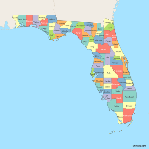 Colored Map of Florida Counties with Surrounding Areaspng730 KB
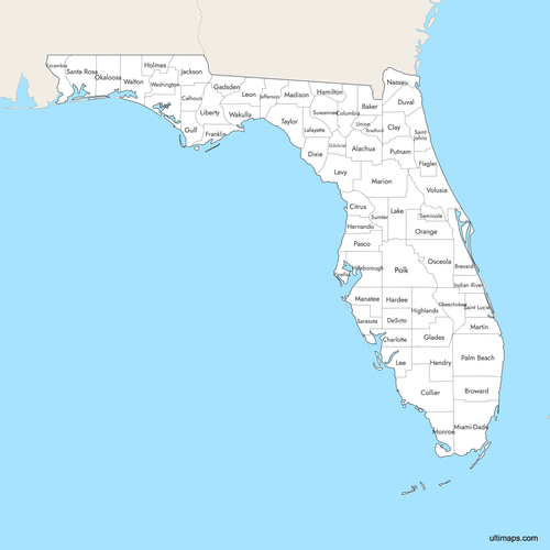 Labeled Map of Florida Counties with Surrounding Areaspng716 KB
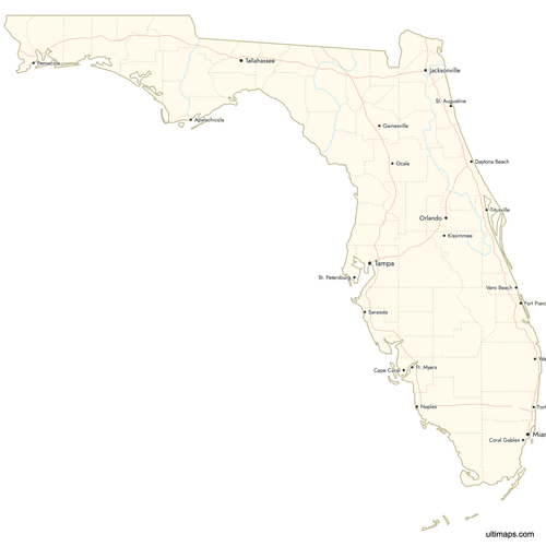 Map of Florida Counties with Citiespng738 KB
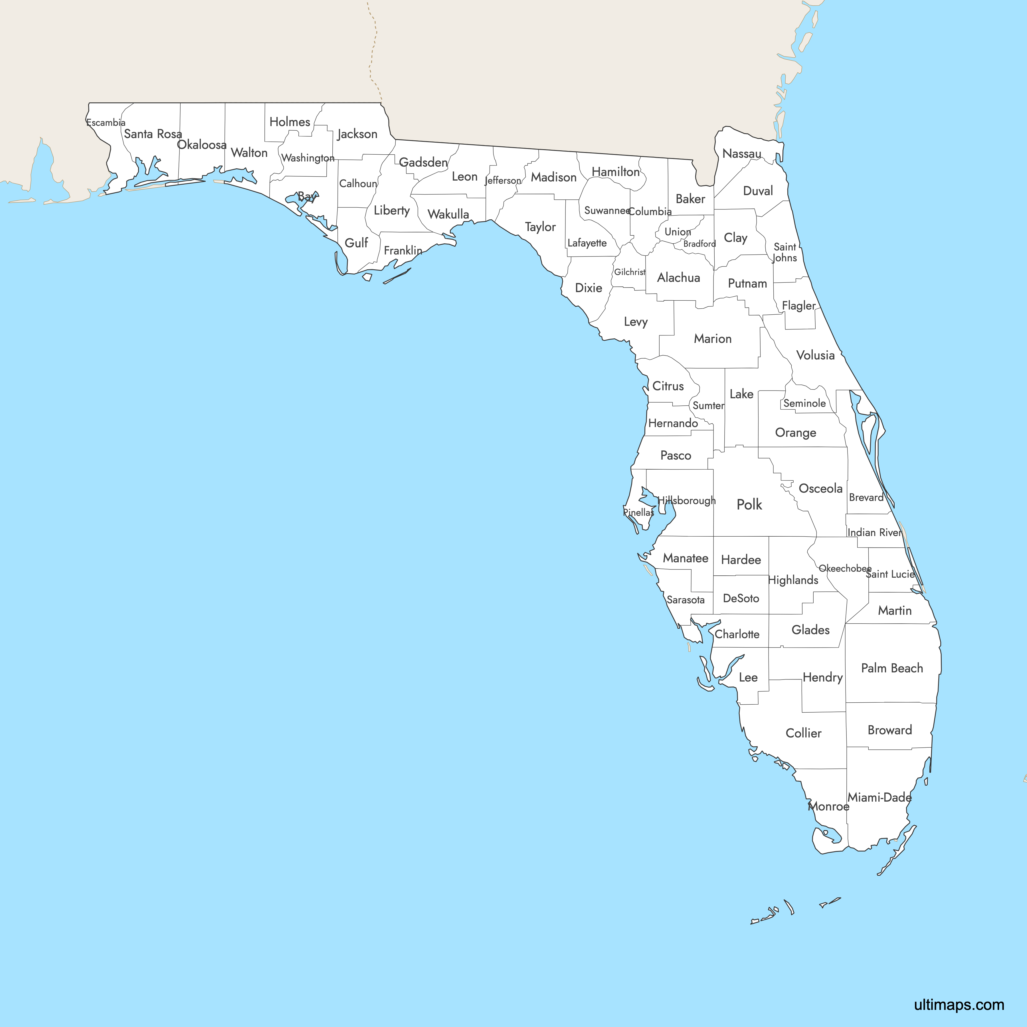
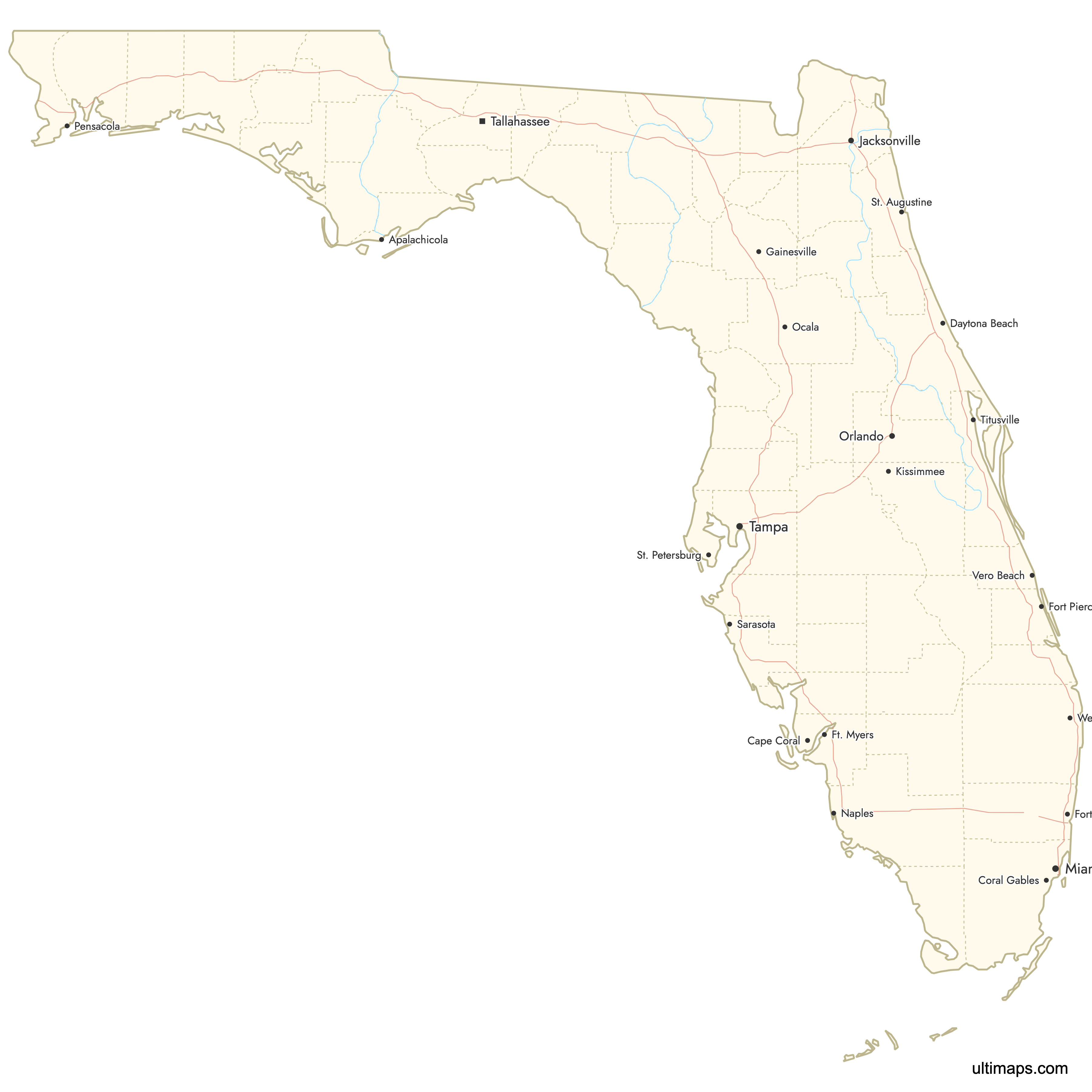
Need it without colors? The blank version of this map comes as a print-ready PDF (A4 and US Letter), a PNG and an editable SVG.
Custom Map Features
This map supports labels.
This map supports surrounding areas, roads, rivers and cities. New
This map is divided into 67 counties.
Updates
Aug 27, 2025:
- Improved map quality
- Added support for surrounding areas and lakes
Aug 26, 2024:
- Added map of Florida Counties
Frequently Asked Questions
Florida has 67 counties.
The most populous counties in Florida include Miami-Dade, Broward, and Hillsborough, which are part of the largest metropolitan areas in the state.
Florida has 35 coastal counties, which play a crucial role in the state's economy, tourism, and environmental management.
Yes, you can download free reference maps of Florida counties from the Ultimaps website without signing up.
You can use Ultimaps to create custom maps of Florida. Color-code counties manually or upload data, place pins, customize look and feel and export to PNG, PDF or SVG.