Romania Map with Counties
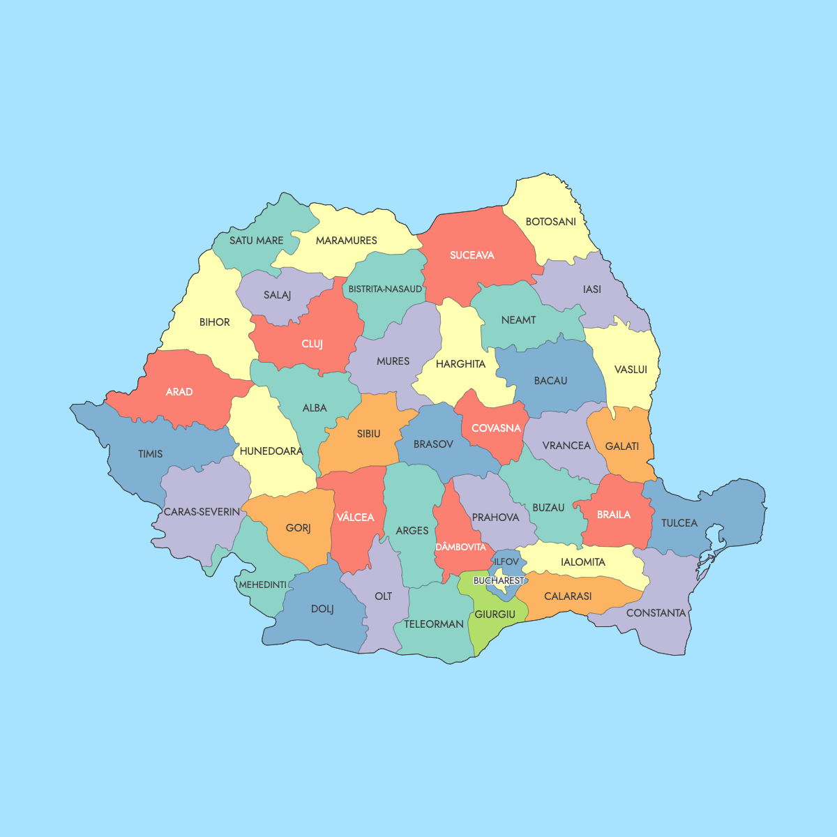
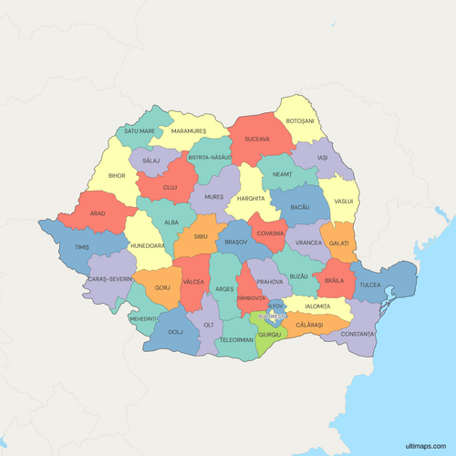
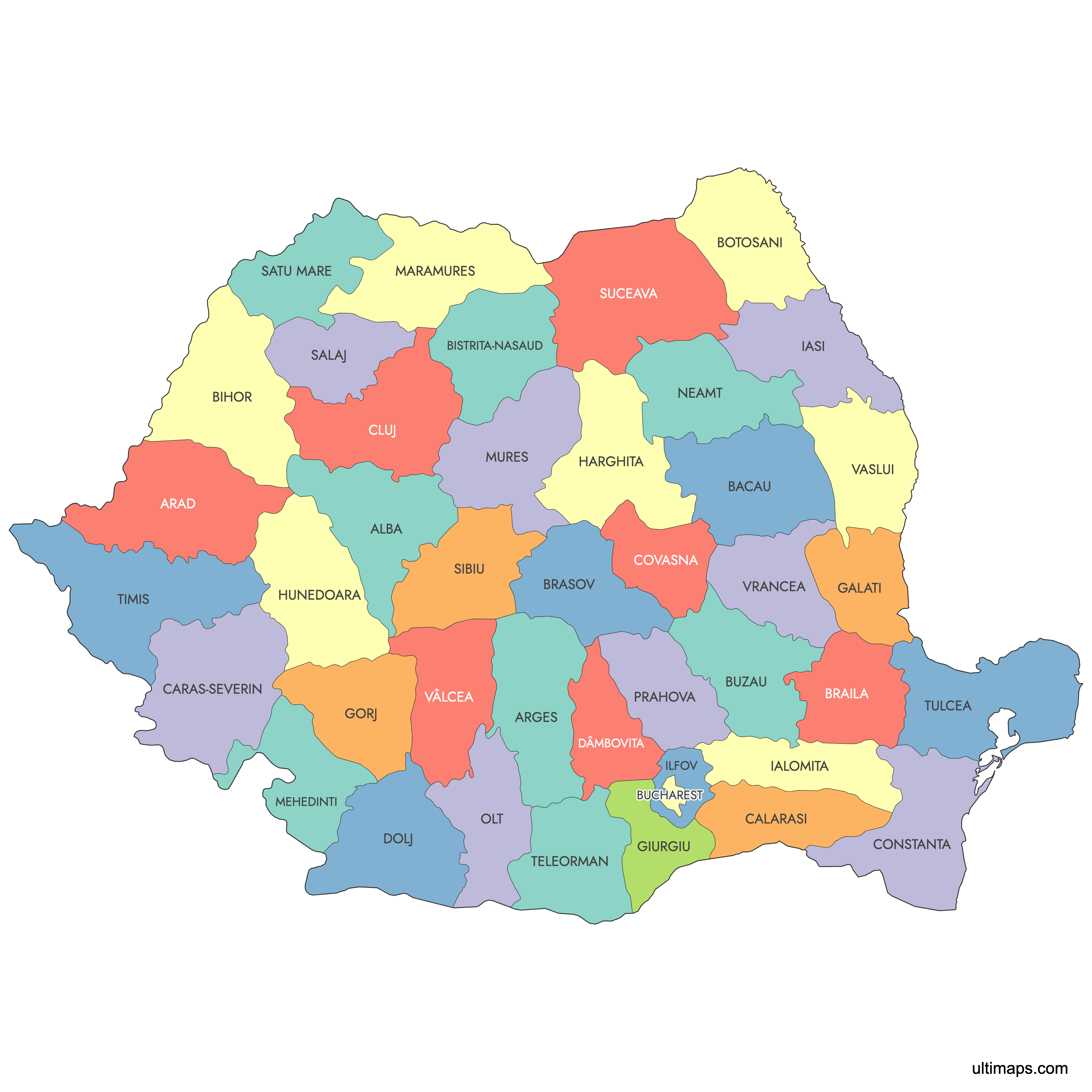
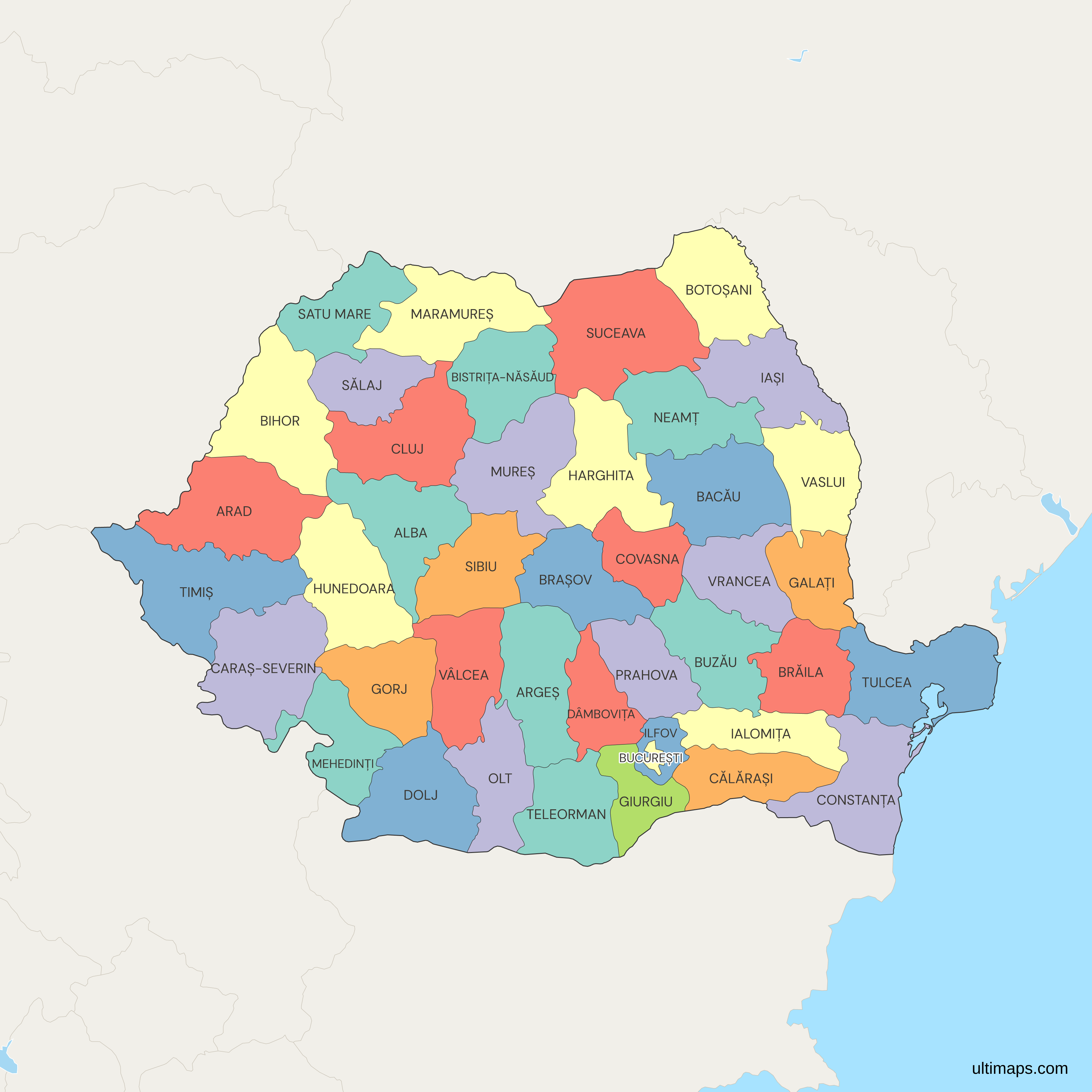
Romania's county map on this page shows 41 counties, known in Romanian as județe, plus the Municipality of Bucharest, the national capital. Bucharest has county-level status without being a county, so the map draws 42 units in total (41 + 1). Ilfov County surrounds the capital on all sides. The layout goes back to the 1968 administrative reform, and the most recent change came in 1997, when Ilfov was restored as a county.
The 2021 census by the National Institute of Statistics (INS) counted 1,716,961 residents in Bucharest and 760,774 in Iași, the most populous county. Timiș, on the western border, is the largest county at 8,697 km² (3,358 sq mi) according to INS, and Ilfov is the smallest at 1,583 km² (611 sq mi). If you want a thematic map, paste one value per county into the editor, and it colors the counties and builds a legend from your numbers.
Interactive Romania Map with Counties
List of Counties (42)
| # | County |
|---|---|
| 1 | Alba |
| 2 | Arad |
| 3 | Argeș |
| 4 | Bacău |
| 5 | Bihor |
| 6 | Bistrița-Năsăud |
| 7 | Botoșani |
| 8 | Brăila |
| 9 | Brașov |
| 10 | București |
| 11 | Buzău |
| 12 | Călărași |
| 13 | Caraș-Severin |
| 14 | Cluj |
| 15 | Constanța |
| 16 | Covasna |
| 17 | Dâmbovița |
| 18 | Dolj |
| 19 | Galați |
| 20 | Giurgiu |
| 21 | Gorj |
| 22 | Harghita |
| 23 | Hunedoara |
| 24 | Ialomița |
| 25 | Iași |
| 26 | Ilfov |
| 27 | Maramureș |
| 28 | Mehedinți |
| 29 | Mureș |
| 30 | Neamț |
| 31 | Olt |
| 32 | Prahova |
| 33 | Sălaj |
| 34 | Satu Mare |
| 35 | Sibiu |
| 36 | Suceava |
| 37 | Teleorman |
| 38 | Timiș |
| 39 | Tulcea |
| 40 | Vâlcea |
| 41 | Vaslui |
| 42 | Vrancea |
Romania Counties: Key Facts
- Total number of units: 41 counties (județe) plus the Municipality of Bucharest, for 42 first-level units. All 42 appear on this map, and they are also Romania's NUTS-3 regions in EU statistics.
- Most populous county: Iași (city of Iași), 760,774 residents (2021 census)
- Least populous county: Tulcea, 193,355 residents (2021 census)
- Largest county by area: Timiș, 8,697 km² (3,358 sq mi), per INS
- Smallest county by area: Ilfov, 1,583 km² (611 sq mi), per INS
- Capital: Bucharest, a municipality with county-level status, 1,716,961 residents (2021 census). Ilfov County surrounds it.
- Counties with major urban centers: Cluj (Cluj-Napoca), Timiș (Timișoara), Iași (Iași), Constanța (Constanța, the main Black Sea port), Brașov (Brașov), Dolj (Craiova), Bihor (Oradea), Prahova (Ploiești), Sibiu (Sibiu)
- Borders: Hungary, Serbia, Bulgaria, Ukraine, Moldova, and the Black Sea coast in Constanța and Tulcea counties
- Time zone: Eastern European Time (EET, UTC+2), with Eastern European Summer Time (EEST, UTC+3) in summer
- Statistical grouping: 8 development regions, created in 1998 as planning units with no administrative powers and now used as Romania's NUTS-2 regions
- Historical note: Law 2/1968 set up 39 counties plus Bucharest. In 1981 Giurgiu and Călărași were created, mostly from former Ilfov County, and Ilfov became a county again in 1997, which brought the total to 41.
Interesting Facts
- Every county has a two-letter code used on vehicle license plates and in ISO 3166-2, for example CJ for Cluj, TM for Timiș and B for Bucharest (RO-B).
- Harghita and Covasna are the two counties where ethnic Hungarians form the majority of the population (2021 census).
- Most of the Danube Delta, a UNESCO World Heritage Site since 1991, lies in Tulcea County, the least populous county.
- Bucharest is divided into six numbered sectors, and each sector has its own mayor and local council.
- The word județ comes from the Latin judicium, meaning judgment. In the medieval Romanian principalities a județ was a territory with both administrative and judicial functions.
Free Downloads
Free for personal and commercial use with a credit to Ultimaps. See the license terms for details.
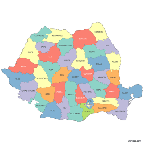 Colored Romania Map with Countiespng666 KB
 Political Map of Romania with Countiespng755 KB
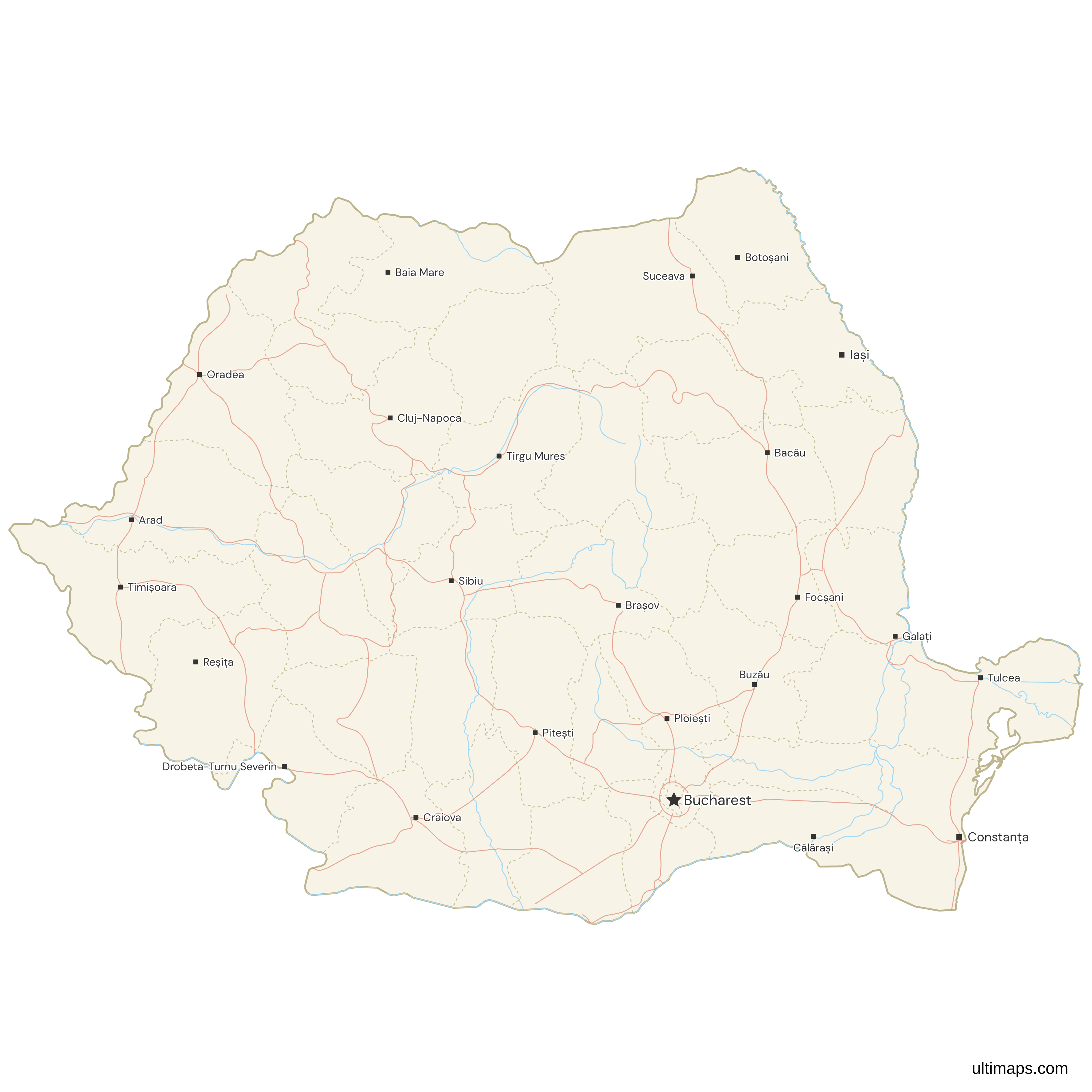
 Map of Romania with Cities and Roadspng861 KB
Need it without colors? The blank version of this map comes as a print-ready PDF (A4 and US Letter), a PNG and an editable SVG.
Custom Map Features
This map supports labels.
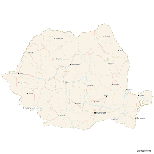
This map supports surrounding areas, roads, rivers and cities. New
This map is divided into 42 counties.
Frequently Asked Questions
Romania has 41 counties, called județe (singular județ), plus the Municipality of Bucharest. Bucharest has county-level status but is not a county, so the country has 42 first-level administrative units, and the map on this page draws all 42 as separate shapes. These 42 units also serve as Romania's NUTS-3 regions in European Union statistics. Each county has a council elected by its residents and a prefect appointed by the national government. The current system dates from Law 2/1968, which created 39 counties plus Bucharest. The total reached 41 after Giurgiu and Călărași were formed in 1981 and Ilfov was restored as a county in 1997.
Bucharest is not a county. The Romanian capital is a municipality with county-level status, so it stands outside the 41 județe and has its own prefect and General Council. Ilfov County surrounds Bucharest on all sides, and the two form the București-Ilfov development region. The 2021 census counted 1,716,961 residents in Bucharest, about 9% of Romania's 19,053,815 people. The city is divided into six numbered sectors, and each sector has its own mayor and local council. On this map Bucharest is a separate shape inside Ilfov, so you can give the capital a value or color that differs from the surrounding county.
Timiș is the largest county in Romania by area at 8,697 km² (3,358 sq mi), according to the National Institute of Statistics (INS). Timiș lies on the western border with Hungary and Serbia, and its seat, Timișoara, is one of the largest cities in the country. At the other end, Ilfov is the smallest county at 1,583 km² (611 sq mi). Bucharest covers less land than Ilfov, but it is a municipality and not a county, so it is not usually included in the county ranking. Romania's total area is 238,397 km² (92,046 sq mi), which means Timiș accounts for about 3.6% of the national territory.
Iași is the most populated county in Romania, with 760,774 residents in the 2021 census. Its seat, the city of Iași, is the main university and administrative center of the historical region of Moldavia in the northeast of the country. Bucharest has more people, with 1,716,961 residents in the 2021 census, but it is a municipality with county status and not a county. Tulcea, which contains most of the Danube Delta, is the least populous county, with 193,355 residents in the 2021 census. Tables based on the 2002 census list Prahova as the most populous county, but Iași has led since the 2011 census.
Romania's 41 counties and Bucharest are administrative units with elected councils, prefects and their own budgets. The 8 development regions are statistical and planning units. They were created in 1998 by grouping neighboring counties, have no directly elected government, and now serve as NUTS-2 regions for EU funding and statistics. The eight regions are Nord-Est, Sud-Est, Sud-Muntenia, Sud-Vest Oltenia, Vest, Nord-Vest, Centru and București-Ilfov. Each region has a Regional Development Council made up of county council presidents and local representatives, with a Regional Development Agency as its executive body. The 42 shapes on this map are the county-level units. If you need a development region map, give every county in a region the same color.
Each Romanian county has a two-letter code. The same letters appear on vehicle license plates and form the second part of the ISO 3166-2 codes, such as RO-CJ for Cluj. Common examples are CJ for Cluj, TM for Timiș, IS for Iași, CT for Constanța and BV for Brașov. Bucharest uses the single letter B, so its ISO code is RO-B. Several codes are hard to guess from the county name: Argeș is AG, Ilfov is IF, Prahova is PH, Vâlcea is VL and Vrancea is VN. These codes are useful in spreadsheets, where a short, fixed code per county is easier to work with than full names that contain diacritics.
Romania's current counties date from Law 2/1968. That law replaced the regions (regiuni) and districts (raioane) introduced in 1950 with 39 counties and the Municipality of Bucharest. Many of the 1968 counties took the names of historical județe abolished in 1950, but their borders were redrawn. In 1981 Ilfov County was broken up. Giurgiu and Călărași became new counties, other parts went to Dâmbovița and Ialomița, and the area around the capital became the Ilfov Agricultural Sector, administered by Bucharest. Ilfov was restored as a county in 1997, which brought the total to 41 counties. The number of counties has stayed at 41 since 1997.
You can build a custom map of Romania's counties in the browser editor on this page. Pick a county and give it a color, or paste a list of values with one row per county and Bucharest, and the editor turns the numbers into a choropleth with a legend. You can place pins on cities, stores or event locations, and change the colors, label text, fonts and border style. The editor is free and does not require an account. Free exports are standard PNG files with a small Ultimaps credit, and the Pro plan adds high-resolution PNG, SVG and PDF export.