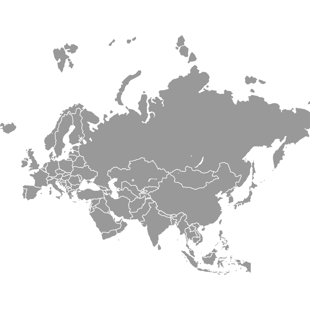
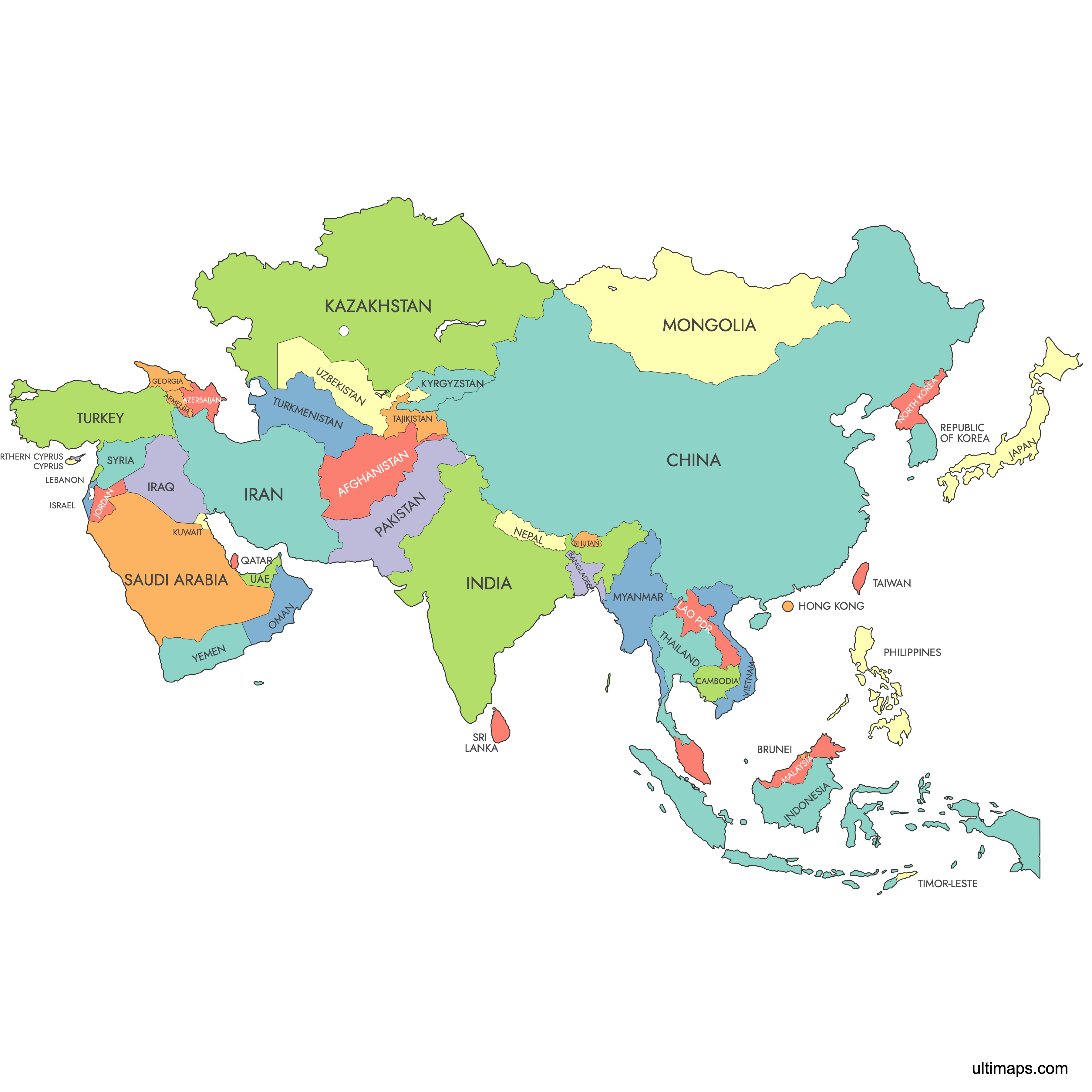
Map of Asia
Asia is the largest and most populous continent on Earth, comprising 48 recognized sovereign countries that stretch from the Ural Mountains in the west to the Pacific Ocean in the east. With major cities such as Tokyo, Delhi, Beijing, and Singapore, the continent is home to extraordinary geographic and cultural diversity. Use the interactive maps below to explore Asia's countries in detail, download free reference maps, or create a custom map to visualize your own data.
Interactive Map of Asia
List of Countries (50)
| # | Country |
|---|---|
| 1 | |
| 2 | |
| 3 | |
| 4 | |
| 5 | |
| 6 | |
| 7 | |
| 8 | |
| 9 | |
| 10 | |
| 11 | |
| 12 | |
| 13 | |
| 14 | |
| 15 | |
| 16 | |
| 17 | |
| 18 | |
| 19 | |
| 20 | |
| 21 | |
| 22 | |
| 23 | |
| 24 | |
| 25 | |
| 26 | |
| 27 | |
| 28 | |
| 29 | |
| 30 | |
| 31 | |
| 32 | |
| 33 | |
| 34 | |
| 35 | |
| 36 | |
| 37 | |
| 38 | |
| 39 | |
| 40 | |
| 41 | |
| 42 | |
| 43 | |
| 44 | |
| 45 | |
| 46 | |
| 47 | |
| 48 | |
| 49 | |
| 50 |
About Asia
- Number of countries: 48 sovereign countries (UN-based count)
- Most populous country: India, 1,463,865,525 (2025 estimate)
- Least populous country: Brunei, 466,330 (2025 estimate)
- Largest country by area: Russia (Asian portion), 13,083,100 km² (5,051,400 sq mi)
- Smallest country by area: Maldives
- Capital: No single capital; Asia is a continent, not a political unit
- Boundaries: Bounded by the Pacific Ocean to the east, the Indian Ocean to the south, and the Arctic Ocean to the north. Separated from Europe by the Ural Mountains, Ural River, Caspian Sea, Caucasus Mountains, and Black Sea. Separated from Africa by the Suez Canal and Red Sea corridor.
- Time zones: UTC+2 (western Asia) to UTC+12 (far eastern islands)
- Major cities: Tokyo (Japan), Delhi (India), Beijing (China), Bangkok (Thailand), Singapore, Dubai (United Arab Emirates), Istanbul (Türkiye), Seoul (South Korea), Jakarta (Indonesia), Kuala Lumpur (Malaysia)
Interesting Facts
- Asia is the largest continent by both area and population, home to well over half of the world's people.
- Several Asian countries are transcontinental. Georgia, Azerbaijan, Russia, Kazakhstan, and Türkiye all have territory in both Asia and Europe, which is why some sources count 49 countries instead of 48.
- Asia spans more than 10 hours of time difference from its westernmost to its easternmost point, covering time zones from UTC+2 to UTC+12.
- The continent contains some of the world's most densely populated megacities, including Tokyo, Delhi, and Jakarta, as well as vast uninhabited deserts and mountain ranges.
Free Downloads
You can download free blank Map of Asia and other maps in high resolution PNG, SVG and PDF formats from the blank maps section of the site: Download Blank Map of Asia
Custom Map Features
This map supports labels.
This map is divided into 50 countries.
Updates
Jul 22, 2014:
- Added map of Asia
Frequently Asked Questions
Asia has 48 sovereign countries according to the UN-based count. Some sources list 49 countries because they include transcontinental states such as Georgia, Azerbaijan, Russia, Kazakhstan, and Türkiye, which have territory in both Asia and Europe.
Russia is the largest country in Asia by area, with its Asian portion covering approximately 13,083,100 km² (5,051,400 sq mi). Russia is also the largest country in the world overall, spanning both Europe and Asia.
The Maldives is the smallest country in Asia by area. It is an archipelago of over 1,000 coral islands in the Indian Ocean, southwest of India and Sri Lanka. Its low-lying geography also makes it one of the most vulnerable countries to rising sea levels.
India is the most populous country in Asia with an estimated population of 1,463,865,525 as of 2025. Its largest city, Delhi, is one of the biggest urban areas in the world. India surpassed China as the world's most populous country in recent years.
Asia is home to many globally significant cities. Tokyo in Japan is one of the world's largest metropolitan areas. Dubai in the United Arab Emirates is known for its modern skyline and rapid development. Seoul in South Korea is a major center for technology and culture.
Asia is bounded by the Pacific Ocean to the east, the Indian Ocean to the south, and the Arctic Ocean to the north. It is separated from Europe by the Ural Mountains, Ural River, Caspian Sea, Caucasus Mountains, and Black Sea. The Suez Canal and Red Sea corridor form the boundary with Africa.
You can use Ultimaps to create custom maps of Asia. Color-code countries manually or upload your data, place pins, customize the look, and export to PNG, PDF, or SVG. No sign-up required.