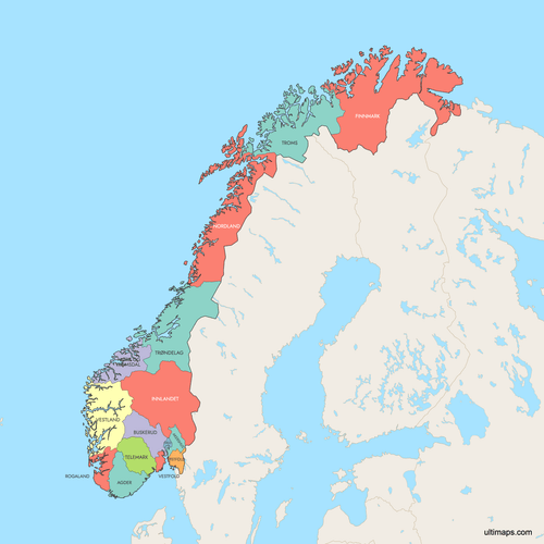
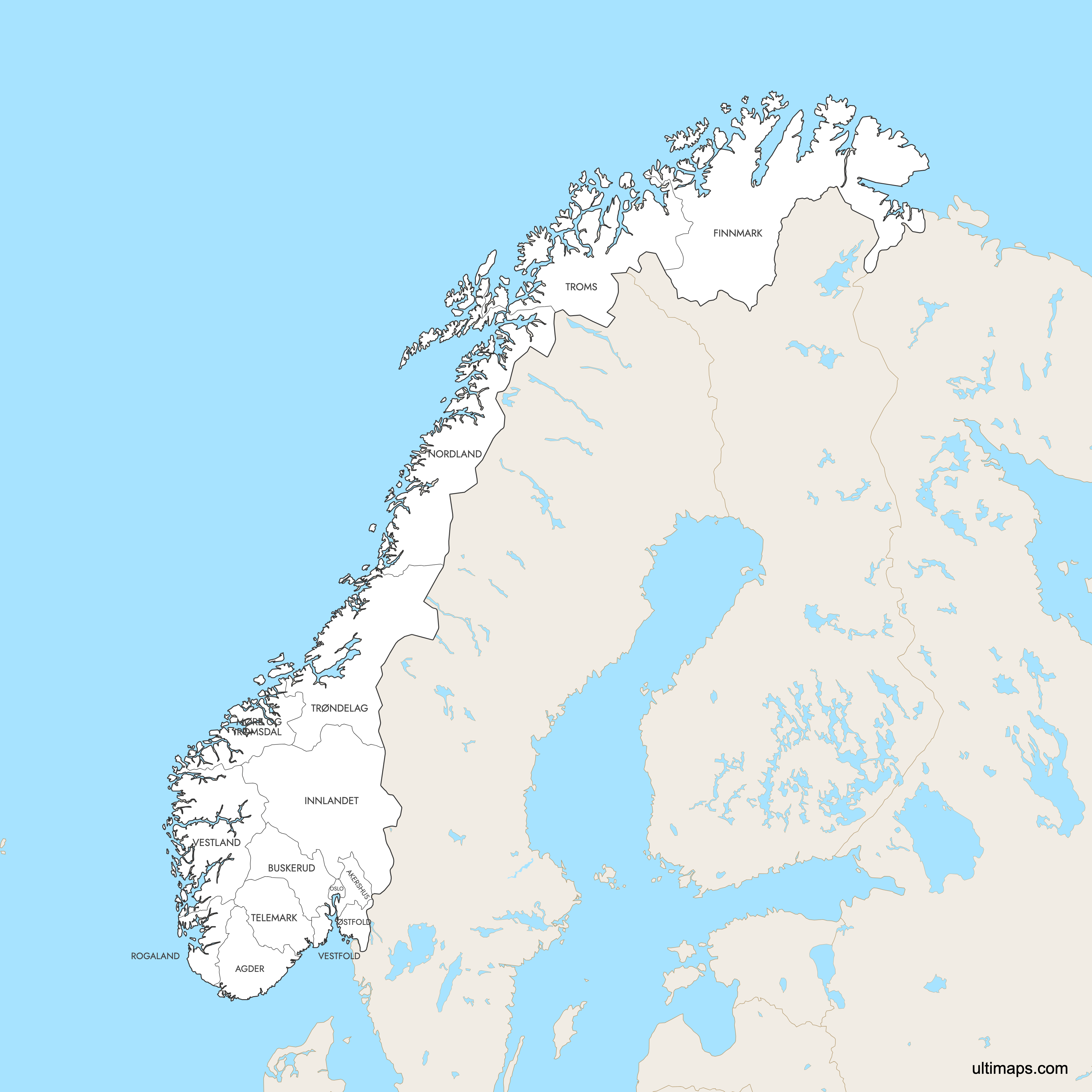
Map of Norway Counties
Norway is divided into 15 counties, known as fylker, each serving as a primary administrative division. Explore the counties and their boundaries with our interactive maps. Download free maps or learn more about creating a custom map of Norway to highlight your own data.
Interactive Map of Norway Counties
List of Counties (15)
| # | County |
|---|---|
| 1 | |
| 2 | |
| 3 | |
| 4 | |
| 5 | |
| 6 | |
| 7 | |
| 8 | |
| 9 | |
| 10 | |
| 11 | |
| 12 | |
| 13 | |
| 14 | |
| 15 |
Norway Counties: Key Facts
- Total number of counties: 15 (as of January 1, 2024), further divided into 357 municipalities
- Largest county by area: Trøndelag — 42,201.59 km² (16,297 sq mi)
- Most populous county: Oslo — 717,710 residents
- Least populous county: Innlandet — 376,304 residents
- Smallest county by area: Oslo — 454.12 km² (175.3 sq mi)
- Counties with major urban centers: Oslo (Oslo), Vestland (Bergen), Rogaland (Stavanger), Trøndelag (Trondheim)
- Recent administrative changes: Viken was abolished in 2024, returning to Akershus, Buskerud, and Østfold
- Governance: County councils elected every four years
- International border: with Russia, Finland and Sweden
- Bordering waters: Norwegian Sea (west), Barents Sea (north), Skagerrak (south)
- Time zone: Central European Time (CET, UTC+1), with Central European Summer Time (CEST, UTC+2) in summer
Interesting Facts
- Oslo's unique status: Functions as both a municipality and a county.
- Historical mergers: Trøndelag was formed in 2018 from Nord-Trøndelag and Sør-Trøndelag.
- 2020 reform partially reversed: Public opposition led to the 2024 restoration of Østfold, Buskerud, Vestfold, Telemark, Troms, and Finnmark as separate counties.
- Akershus surrounds Oslo on three sides, yet its administrative seat is located within Oslo itself.
- Arctic territories outside the county system: Svalbard and Jan Mayen are governed directly by the national government.
- Lillehammer, host of the 1994 Winter Olympics, is located in Innlandet county.
Free Downloads
 Colored Map of Norway Counties with Surrounding Areaspng1532 KB
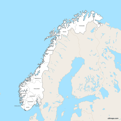 Labeled Map of Norway Counties with Surrounding Areaspng1530 KB
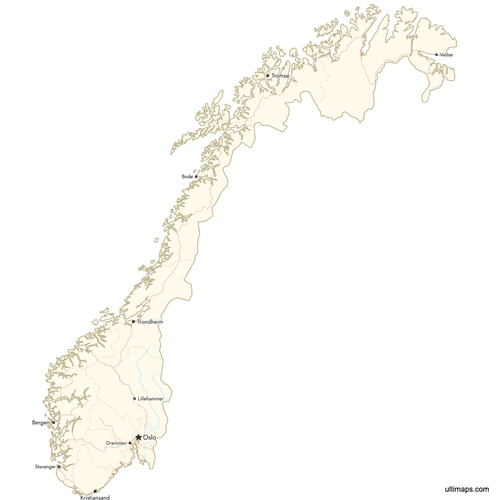 Map of Norway Counties with Citiespng922 KB


You can download free blank Map of Norway Counties and other maps in high resolution PNG, SVG and PDF formats from the blank maps section of the site: Download Blank Map of Norway Counties
Custom Map Features
This map supports labels.
This map supports surrounding areas, roads, rivers and cities. New
This map is divided into 15 counties.
Updates
Apr 15, 2026:
- Added surroundings, roads and cities layer
Jun 17, 2025:
- Added map of Norwegian counties and its labeled version
Frequently Asked Questions
Norway has 15 counties, known locally as fylker.
You can use Ultimaps to create custom maps of Norway. Color-code counties manually or upload data, place pins, customize look and feel, and export to PNG, PDF, or SVG.
Trøndelag is the largest county in Norway by area at 42,202 km² (16,297 sq mi). It was formed in 2018 by merging the former Nord-Trøndelag and Sør-Trøndelag counties, and its major city is Trondheim.
Oslo is the smallest county in Norway by area at just 454 km² (175.3 sq mi). Despite its small size, Oslo is the most populous county and serves as both the national capital and a standalone municipality.
Oslo is the most populated county in Norway with approximately 717,710 residents. It uniquely functions as both a county and a municipality, and is the political, economic, and cultural center of Norway.
Bergen, Norway's second-largest city and a major port, is in Vestland county. Stavanger, the country's oil industry hub, is in Rogaland county. Trondheim, a historic former Viking capital, is in Trøndelag county. Lillehammer, host of the 1994 Winter Olympics, is in Innlandet county.
In 2020, Norway merged 19 counties into 11 as part of a regional reform initiated by the Solberg government. Public resistance to the mergers led to a partial reversal on January 1, 2024, when the number increased to 15. Viken was dissolved back into Akershus, Buskerud, and Østfold, while Vestfold og Telemark and Troms og Finnmark also split into separate counties.
Norway shares land borders with Sweden to the east, and Finland and Russia to the northeast. It is surrounded by the Norwegian Sea to the west, the Barents Sea to the north, and the Skagerrak strait to the south. Norway's Arctic territories of Svalbard and Jan Mayen lie outside the county system.
A county (fylke) is Norway's primary administrative division, handling regional governance through elected councils. Municipalities (kommuner) are subdivisions within counties that manage local services. Norway has 15 counties and 357 municipalities. Oslo is unique in that it serves as both a county and a single municipality.